FAQ
Walking the Tube:
Answers to your common queries.
What is TubeWalk++++ about?
Let me start by saying Tubewalk isn’t my idea, I got it from Mark Moxon’s website.
I’ve added extra parts to make it more challenging, this is where the ++++ comes from.
This website is to document my walking adventure around London’s transport network.
Completing the challenge in a fairly short time but allowing for a reasonable recovery time between each walk. This typically means up to 3 walks per week of up to 50 miles in total depending on the weather as I definitely don’t like rain and can’t be bothered getting proper rain gear.
I also have an overall average speed target of 4.4 mph to keep the challenge interesting.
How can I support your mission?
You contribute through donations to my nominated charity and going outside and trying some of it out for yourself. You’ll get something out of walking even just a few stops on a line.
Which lines are included?
- 11x Underground
Bakerloo, Central, Circle, District, Hammersmith & City, Jubilee,
Metropolitan, Northern, Piccadilly, Victoria, Waterloo & City - 6x Overground
Liberty, Lioness, Mildmay, Suffragette, Weaver, Windrush - DLR
- Elizabeth Line
- Tramlink
- River Bus
RB1, RB2, RB4, RB6
Each station and pier only has to be visited once, not once for each line it’s on.
How much have I spent on fares?
Breakdown of fares for the various walks
Why walk the TfL network?
To get out of the house, get some fresh air and exercise and to raise money for charity at the same time. Also to construct this website to show my progress and as a challenge to aspire to.
Other marked trails in London…TfL’s Walk London
TfL maintain a significant number of trails within the Greater London area.
Some are shorter than others but generally have stages that aren’t too long if you’re a beginner.
There are other trails you can follow, such as the GMT trail inside the M25
I’ve completed most of these which led me to look for a new challenge.
Walking a Marathon distance around Central London was challenging but not enough,
say hello to Tubewalk++++.
What’s next? Probably a rucksack and a tent.
All the gear … but no idea
I’m using the following gear to plan and execute Tubewalk++++
- Garmin Epix GPS watch to navigate and record my walks
- PlotaRoute to plan the routes and create GPX files to use with Garmin Connect / Epix
- A spreadsheet to manage the walks
- Asics Gel Nimbus 26 shoes
- Garmin Connect to show where I walked as well as some metrics
- Panasonic TZ-99 compact camera
- Motorola Moto G55 smartphone
How far is far?
When you use a route planner like PlotaRoute it calculates distance from digitial mapping data. Typically it draws the routes to follow roads, either on the left or right or in the centre.
If the map you’re using has footpaths then it can follow those, but there isn’t 100% coverage of footpaths. This leads to routes that you cannot actually walk but can be close to.
Google Earth lets you draw more accurate paths as you can see the pavements and draw routes along them. You can then export those routes and load them in PlotaRoute.
If you find a 400m althetics track in Google Earth and draw a path around the inside of lane 1 the distance will be 400m, so you know Google Earth is accurate.
When you record a walk using an Epix watch it can record your position every second.
Then you can look at the saved path in Garmin Connect. The first thing you’ll notice is the path can deviate from where you walked. This effect is more noticeable when walking amongst tall buildings eg. in Canary Wharf or the City of London.
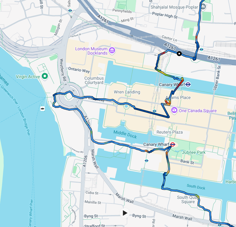
So there are various versions of the distance available and the GPS measure tends to be lower than the PlotaRoute measure. The most accurate is the Google Earth measure but
even then you’d have to walk the actual path which is unlikely. The Epix navigation capability lets you follow a route but there’s at least 10m of wiggle room around that path before it indicates you’re not on the path any more.
Another factor is the path I walk – wherever possible I walk the inside of curves and cross roads diagonally, which basic trigonometry tells us results in a lower distance compared to crossing roads perpendicuarly which is how the route planner tends to do it.